Creating Middle-Earth Weather
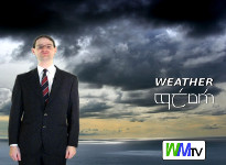
My initial creative vision was clear: I wanted to create a spoof TV weather forecast for Middle-Earth along the same lines as earthly TV weather bulletins. But where on Middle-Earth do you start?
This is part one of a two-part article. Part one is about the research and pre-production; part two is about the filming and post-production process.
Structure and politics
Every weather bulletin has the same basic structure: start with how things are now, talk in detail about the next day or so, then hint at the outlook for the following couple of days. That much was clear. However, where would my details come from? Well, as the forecast was going to be broadcast on something approximating television, I found myself wondering, what area was the station going to broadcast to and who would it serve? These questions turned out to be key.
Middle-Earth has several widespread races and, as we know, there are tensions amongst some of them. Would a regional broadcast station with the King’s implicit blessing perhaps have a charter requiring it to be seen to serve all the major communities of the area? In other words, I had a perfect excuse to have the bulletin nod explicitly to elves, dwarves and hobbits alike.
Claire and I thought hard about how to weave this into the overall structure of the bulletin.
Tolkien’s elves are reknowned for their particularly good eyesight, so I made reference to the visibility, which is of course a direct result of the weather. Those of Lothlorien constructed platforms in trees, flets, which gave me another angle: I surmised that high winds could pose a structural risk worth mentioning, much in the same way that earthly weather bulletins warn of heavy rain and so forth.
The hobbit lifestyle is typically quiet and agrarian. What would they be interested in? Well, their crops, of course; how fast their laundry dries, perhaps whether there was going to be a wind blowing directly from Mordor which would upset their hens.
Dwarves live mostly underground. This rapidly led to the idea that they’d be interested in the water levels in cave systems. Of course, they’re experienced miners - but even so advance warning of a flood might be of good use to them. (The question of how a television signal would reach the depths of Moria is left for the reader. Perhaps they have cable, or perhaps some poor soul is dispatched to climb the Endless Stair to adjust the antenna whenever reception is poor.)
Finally, the residents of Middle-Earth generally take more of an interest in stargazing than we do. Obviously, then, the bulletin ought to make reference to this: when does Eärendil rise? What is the phase of the moon? What is the sky going to be like for stargazing tonight, anyway?
Weather patterns

We know so much about the geography and climate of Middle-Earth from Tolkien’s own writings that it is possible to talk about weather patterns in a serious and consistent fashion. Karen Wynn Fonstad’s Atlas of Middle-Earth helped a lot by gathering the climatic information in one place. Being a bit of a weather nerd I already knew something of how weather patterns are generated, so I extrapolated from there to the terrain of Middle-Earth.
At one level, it’s all about the air. Air takes on lingering characteristics of wherever it has been: wet/dry, hot/cold, dust/pollution. When air is saturated with water vapour, any further cooling causes a cloud to form; when there’s enough water present at a high enough density, it starts to precipitate out - usually as rain.
The air also interacts with the terrain. Air blowing in from the sea tends to be wet; if there’s enough to rain, it falls on the windward side of the land and any mountains there may produce a rain shadow effect. This means that if, say, a band of rain were to move northwards off the sea, Gondor would be a rather wet place, the Misty Mountains particularly so (perhaps with hill fog) but Rohan would experience dry conditions, if a bit murky.
Before I knew it I had invented the bones of some actual weather conditions I could talk about!
Cartography
First base map
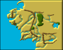
A TV weather forecast is nothing without a map. Sorting out my base map was probably the most time-consuming part of the whole exercise.
Even if copyright wasn’t an issue, the maps in LotR itself and the Atlas weren’t directly suitable for a televisual medium; it was clear that I was going to have to redraw the map myself.
Bevelled 3D effect
It was time to break out Inkscape, the free (if slightly slow) vector graphics package, being the most plausible tool for the job (not counting those which I’d have had to pay for).
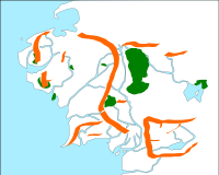
I found myself constructing a rough map outline by hand-drawing and hand-tracing from the two sources, frequently comparing the two. Eventually, I had a plausible if rough and jagged outline, which I then smoothed with machine assistance. A coloured underlay represented the ocean, seas and major rivers; layering the shapes of the mountains and forest areas on top brought me to the version of my base map (pictured).
So far so good. However I needed my map to be visually striking; there was a lot of to-ing and fro-ing before I settled on the final colour scheme. I also wanted it to feel like it had a bit of depth to it. Fortunately, Inkscape has a number of effect filters, which I had previously only scratched the surface of. I spent some time plumbing the depths before settling on a bevel to give a 3D effect.
Drawing the weather
With the base map complete, I could at last start drawing isobars and attaching weather symbols. I spent some time scrawling on a hard copy figuring out a consistent underlying weather pattern which had the results I wanted; some of this time I was working widdershins, first deciding what I wanted to say, then figuring out what underlying patterns would have caused it and working them back into the master synoptic chart.
When it comes to putting the weather onto the screen, broadcast professionals have software that makes this very easy and straightforward. However, I was slumming it with Inkscape. I didn’t even have weather symbols, but luckily Google and the Tango Desktop Project came to my rescue.
Volcano!
I had already decided that the air would be blowing south-easterly from Mordor so I could talk about the need to keep one’s hens and horses happy. Claire hit upon the idea to relate the bad air back to earthly forecasts in a pastiche of the air quality index - and so the Mordor index was born.
It was the summer of 2010; air traffic across Europe had been disrupted by an ash cloud from Eyjafjallajökull, a volcano in Iceland whose name most broadcasters had rather wisely decided they would not attempt to pronounce. It quickly became clear that the bad air coming from Mordor could be exacerbated by the effects of a volcanic eruption nearby, and that the resultant ash cloud would be too thick to fly a Nazgul through. I then realised that I could make a further topical gag out of not actually naming the volcano; perhaps its name was itself in the Black Speech.
Tengwar
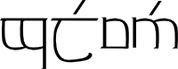
gwelwen, or 'weather'
As the set of slides was coming to completion, I wondered about adding some Tengwar to boost the LotR ambience. After all, the aforementioned demographic politics might positively require it, so I set out to find some plausible words to add to the captions.
A few enthusiasts have created Tengwar fonts, but I didn’t rate my chances of being able to make those work with Linux in a reasonable amount of time. I decided to draw them - again using Inkscape - though I was able to exploit the similarities amongst the individual tengwar by cutting and pasting strokes to save time.
Starting with the title slide, then, gwelwen (pictured) was the closest Sindarin word I could find to weather, meaning air or atmosphere. Evening and Daytime translated straight across (aduial and arad), and in place of Monday I used orgilion, the first day of the Numenorean week.
That left the skywatching slide, which was to prove a little sticky. Eärendil itself was uncontroversial (though I used tengwar in the Quenya mode, that being the spelling I was able to readily find), but what about the time on the slide, which I arbitrarily decided would be 9:05pm…? I wasn’t able to readily determine how times were written, so I just took the 24-hour clock and wrote out the Tengwar numerals for it (right-to-left, of course). In fact I went out on a limb and wrote 2005, surmising that the main Elvish communities were sufficiently far to the west of Gondor as to justify a different timezone, which I named for Eriador. (We know that aneroid barometers and chiming clocks existed on Middle-Earth by the end of the Third Age, because Tolkien himself mentions them - so surely some clever hobbit or elf would have noticed that the sun sets about four minutes later for every league and a half you travel to the west and come up with the notion of local time?)
Finally, my slides were complete. It was time to actually film it, but that’s to come in part two…